Our Products
- Home
- Our Products
-
Asphalt/ Bitumen Equipment's
-
Concrete TestingBlaine Air Permeability Cementometer Chlorimeter Compaction Factor Apparatus Compression Testing Machine Concrete Permeability Apparatus Cube Mould Curing Tank Direct Shear Flexural Strength Testing Machine Flow Table High Performance Ultrasonic Pulse Velocity Laboratory Pan Mixer Longitudinal Compressometer Mortar Mixer Mortar Penetrometer Pocket Ultrasonic Tester Rebound Hammer Tile Abrasion
-
Soil TestingAggrameter Aggregate Crushing Value Apparatus Aggregate Impact Value Test Aquaprobe Benkelman Beam Apparatus Buoyancy Balance California Bearing Ratio Apparatus Cone Penetrometer Digital Los Angeles Abrasion Testing Machine Direct Shear (Variable Speed) Le-Chatlier Mould Liquid Limit Pavement Dynamic Cone Penetrometer Plastic Limit Sand Equivalent Value Apparatus Sand Pouring Cylinder Shrinkage Limit Sieves
-
Surveying
GPS
Entry-point into Leica iCON GNSS performance:
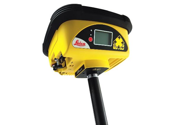
Easy to use and equipped with the construction tailored Leica iCON site field software, the iCON gps 30 facilitates your entry into the Leica iCON GNSS portfolio.
Lightest pole weight:
The light, compact and balanced design makes it comfortable to use and carry in the field.
Reliable and accurate measurement results:
With the highest level of position reliability in its class, the iCON gps 30 delivers accurate results and increases productivity. Take the first step into Leica iCON construction workflows with Leica Geosystems’ entry-level GNSS RTK rover. The iCON gps 30 is designed to assist construction companies move forward from traditional, to modern digital stakeout and measurement methods. Experience faster workflows, with accurate results and higher efficiency in construction projects, such as utility or road construction. Using advanced RTK technologies the rover delivers consistently accurate and reliable positions. Integrated into the well-established and construction tailored iCON site field software, the iCON gps 30 speaks the language of construction site professionals.
Make : Leica, Switzerland
Specification
GNSS PERFORMANCE
| GNSS Technology | Leica RTKplus | Adaptive on-the-fly satellite selection |
|---|---|---|
| Signal tracking | SmartTrack | GPS (L1, L2, L2C, L5), Glonass (L1, L2, L31), BeiDou (B1, B2, B31), Galileo (E1, E5a, E5b, Alt-BOC, E61) |
| Leica SmartCheck | Continuous check of RTK solution | Reliability 99.95% |
| Number of channels | 320 hardware channels | |
MEASUREMENT PERFORMANCE & ACCURACY2
| Time for initialisation | Typically 6 s | |
|---|---|---|
| Real-time kinematic (Compliant to ISO17123-8 standard) |
RTK, Multifrequency | Hz 10 mm + 1 ppm / V 20 mm + 1 ppm |
| Code differential | DGPS / RTCM | Typically 25 cm |
COMMUNICATIONS
| Communication ports | Lemo Bluetooth® |
USB and RS232 serial Bluetooth® 4.1 class 1 & sealed and protected 8-pin Lemo combined USB / Serial232 port |
|---|---|---|
| Communication protocols | RTK data protocols Network RTK |
Leica, Leica4G, CMR, CMR+, RTCM 2.2, 2.3, 3.0, 3.1, 3.2 MSM VRS, FKP, iMAX, MAC (RTCM SC104) |
| External data links | UMTS / LTE / CDMA phone modem |
GENERAL
| Field software and controller | Leica iCON site | Leica iCON CC70 / CC80 field controller |
|---|---|---|
| User interface | Buttons and LEDs | On / Off button, 3 status LEDs |
| Power management | Internal power supply External power supply Operation time3 |
Exchangeable Li-Ion battery (2.6 Ah / 7.4 V) Nominal 12 V DC, range 10.5 – 28 V DC 8 h GNSS 7 h receiving RTK data with CC70 modem |
| Weight and dimensions | Weight Diameter x Height |
0.7 kg / 2.5 kg standard RTK rover setup on pole 186 mm x 71 mm |
| Environmental | Temperature Drop Proof against water, sand and dust Vibration Humidity Functional shock |
-40 to 65°C operating, -40 to 80°C storage Withstands topple over from a 2 m survey pole onto hard surfaces IP66/IP68 (IEC60529 / MIL STD 810G CHG-1 510.6I / MIL STD 810G CHG-1 506.6 II / MIL STD 810 G CHG-1 512.6 I) Withstands strong vibration (ISO9022-36-05 / MIL STD 810G 514.6 Cat.24) 95% (ISO9022-13-06 / ISO9022-12-04 / MIL STD 810G CHG-1 507.6 II) 40 g / 15 to 23 msec (MIL STD 810G 516.6 I) |
-
Asphalt/ Bitumen Equipment's
-
Concrete TestingBlaine Air Permeability Cementometer Chlorimeter Compaction Factor Apparatus Compression Testing Machine Concrete Permeability Apparatus Cube Mould Curing Tank Direct Shear Flexural Strength Testing Machine Flow Table High Performance Ultrasonic Pulse Velocity Laboratory Pan Mixer Longitudinal Compressometer Mortar Mixer Mortar Penetrometer Pocket Ultrasonic Tester Rebound Hammer Tile Abrasion
-
Soil TestingAggrameter Aggregate Crushing Value Apparatus Aggregate Impact Value Test Aquaprobe Benkelman Beam Apparatus Buoyancy Balance California Bearing Ratio Apparatus Cone Penetrometer Digital Los Angeles Abrasion Testing Machine Direct Shear (Variable Speed) Le-Chatlier Mould Liquid Limit Pavement Dynamic Cone Penetrometer Plastic Limit Sand Equivalent Value Apparatus Sand Pouring Cylinder Shrinkage Limit Sieves
-
Surveying

